


Editor's note: This story will be updated as more information comes in.
Lancaster County residents are waking up to a coat of snow Tuesday, bringing cold and windy conditions to the rest of the week.
Through early Tuesday afternoon, 2 to 4 inches of snow is predicted to fall, according to Kyle Elliott, director of Millersville University’s Weather Information Center. Most of the snow will be over Monday night, but there’s a good chance of light snow Tuesday morning before exiting around midday.
Temperatures will stay in the 20s, so according to Elliott, the ground will be snow-covered and slippery, making a slow and difficult commute Tuesday morning.
PennDOT initially reduced speed limits on major Lancaster County highways to 45 mph, but those restrictions have since been removed.
Scenes from around Lancaster County during the second snow of 2024 [photos]
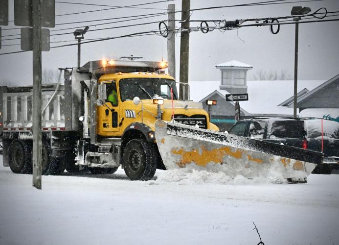
A PennDOT plow clears Columbia Avenue near Rohrerstown Road in East Hempfield Township on Tuesday, Jan. 16, 2024.
- BLAINE SHAHAN | Staff Photographer
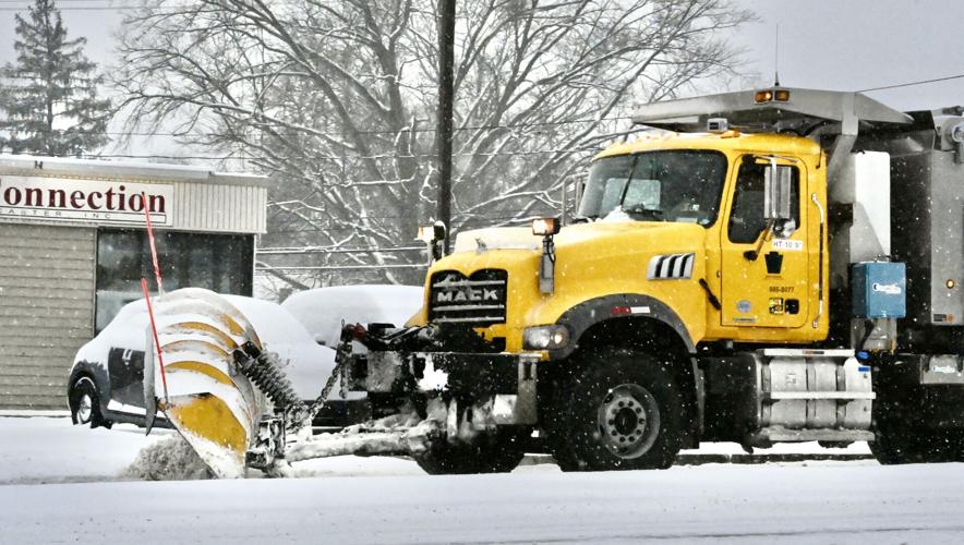
A PennDOT plow clears Columbia Avenue near Millersville Road in Manor Township on Tuesday, Jan. 16, 2024.
- BLAINE SHAHAN | Staff Photographer

Catherine Elliott, left, and Heather Smith, both of Lancaster city, ride a tube down the snow covered hill at Buchanan Park, in Lancaster city, on Tuesday, Jan. 16, 2024
- BLAINE SHAHAN | Staff Photographer

William Elliott, left, and Stuie Smith, both of Lancaster city, ride a tube down the hill at Buchanan Park, in Lancaster city, on Tuesday, Jan. 16, 2024
- BLAINE SHAHAN | Staff Photographer

Ashley Ulis, of Lancaster city, and her daughter Samantha, sled down the hill at Buchanan Park, in Lancaster city, on Tuesday, Jan. 16, 2024
- BLAINE SHAHAN | Staff Photographer

Stuie Smith, 8, of Lancaster city, slides down the hill at Buchanan Park, in Lancaster city, on Tuesday, Jan. 16, 2024
- BLAINE SHAHAN | Staff Photographer

Ethan Ulis, 10, of Lancaster city, slides down the hill at Buchanan Park, in Lancaster city, on Tuesday, Jan. 16, 2024
- BLAINE SHAHAN | Staff Photographer

Mathilda, left, and William Elliott, of Lancaster city, get a push from their mother Catherine as the sled at Buchanan Park, in Lancaster city, on Tuesday, Jan. 16, 2024
- BLAINE SHAHAN | Staff Photographer

Two horses sniff at the snow along the 1200 block of West Penn Grant Road in Lancaster, at the Trevelyan Farm on Tuesday, Jan. 16, 2024.
- SUZETTE WENGER | Staff Photographer

George Dochat shovels his driveway along the 800 block of West Penn Grant Road in Willow Street on Tuesday, Jan. 16, 2024.
- SUZETTE WENGER | Staff Photographer

George Dochat shovels his driveway along the 800 block of West Penn Grant Road in Willow Street on Tuesday, Jan. 16, 2024.
- SUZETTE WENGER | Staff Photographer

George Dochat shovels his driveway along the 800 block of West Penn Grant Road in Willow Street on Tuesday, Jan. 16, 2024.
- SUZETTE WENGER | Staff Photographer

A scenic farm view photographed from Church Road looking at the 1400 block of West Penn Grant Road in Pequea Township on Tuesday, Jan. 16, 2024.
- SUZETTE WENGER | Staff Photographer

Old tractor equipment sits at Restoration Tractor Sales on the first block of Church Road in Lancaster on Tuesday, Jan. 16, 2024.
- SUZETTE WENGER | Staff Photographer

An unmarked snow plow makes its way down the 800 block of West Penn Grant Road in Willow Street on Tuesday, Jan. 16, 2024.
- SUZETTE WENGER | Staff Photographer

Bill Shelley plows the front lot at Pequea Elementary School on Millwood Road in Willow Street on Tuesday, Jan. 16, 2024.
- SUZETTE WENGER | Staff Photographer

Bill Shelley plows the front lot at Pequea Elementary School on Millwood Road in Willow Street on Tuesday, Jan. 16, 2024.
- SUZETTE WENGER | Staff Photographer

Two barns sit along the 100 block of Silver Mine Road in Conestoga on Tuesday, Jan. 16, 2024.
- SUZETTE WENGER | Staff Photographer

The Silver Mine Run flows south toward the 100 block of Silver Mine Road near the Silver Mine Park in Conestoga on Tuesday, Jan. 16, 2024.
- SUZETTE WENGER | Staff Photographer

The Silver Mine Run flows south along the 100 block of Silver Mine Road at the Silver Mine Park in Conestoga on Tuesday, Jan. 16, 2024.
- SUZETTE WENGER | Staff Photographer

An old historic home sits along the 100 block of Silver Mine Road on the southern side of the road at the Silver Mine Park in Conestoga on Tuesday, Jan. 16, 2024.
- SUZETTE WENGER | Staff Photographer

The Pequea Creek as viewed from the bridge crossing the water along Sand Hill Road just south of Sickman's Mill in Pequea on Tuesday, Jan. 16, 2024.
- SUZETTE WENGER | Staff Photographer

A plow pushes snow from West Clay Street near North Queen Street in Lancaster city on Tuesday, Jan. 16, 2024.
- BLAINE SHAHAN | Staff Photographer

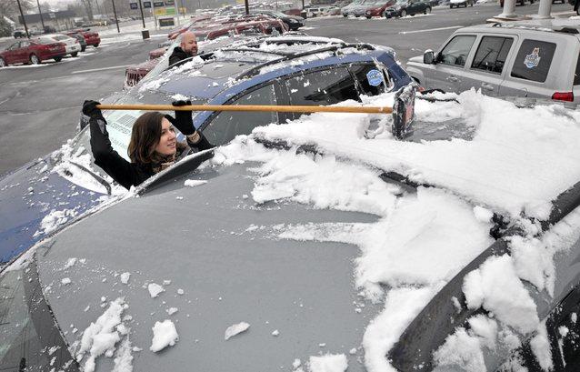
Selvin Lobeo brushes snow from a vehicle in the 1000 block of Marshall Avenue in Manheim Township Tuesday, on Jan. 16, 2024.
- BLAINE SHAHAN | Staff Photographer

Snow piles up on a lamp post along Sunnyside Road in Mt. Joy Twp. Tuesday Jan. 16, 2024.
- CHRIS KNIGHT | Staff Photographer

Winds whip the snow from the roof of this barn along Sunnyside Road in Mt. Joy Twp. Tuesday Jan. 16, 2024.
- CHRIS KNIGHT | Staff Photographer

Trees dusted by snow along Sunnyside Road in Mt. Joy Twp. Tuesday Jan. 16, 2024.
- CHRIS KNIGHT | Staff Photographer

Trent Martin, right, his wife Melissa Martin and Jo Martin, 1, take a stroll in the snow along South Fulton Street in Manheim Tuesday Jan. 16, 2024.
- CHRIS KNIGHT | Staff Photographer

Craig Steinmetz shovels the snow off his sidewalk along Ferdinand Street in Manheim Tuesday Jan. 16, 2024.
- CHRIS KNIGHT | Staff Photographer

Bruce Shaffer, cleans the snow off his car along Granby Street in Manheim Tuesday Jan. 16, 2024.
- CHRIS KNIGHT | Staff Photographer

Marissa Helderman, 18, freom Lititz, snowboards down Bomberger's Hill in Warwick Twp. Tuesday Jan. 16, 2024.
- CHRIS KNIGHT | Staff Photographer

Sledders make their way back up Bomberger's Hill in Warwick Twp. Tuesday Jan. 16, 2024.
- CHRIS KNIGHT | Staff Photographer

Caleb Jerchau, 13, right, and his brother Seth Jerchau, 16, both from Lititz, snow board down Bomberger's Hill in Warwick Twp. Tuesday Jan. 16, 2024.
- CHRIS KNIGHT | Staff Photographer

Brian Couch and his daughter Aubrey Couch, 6, both from Lititz, blast through the snow as they sled down Bomberger's Hill in Warwick Twp. Tuesday Jan. 16, 2024.
- CHRIS KNIGHT | Staff Photographer
The National Weather Service announced a winter storm warning in the county that expired at noon Tuesday. Winter storm warnings are issued for a significant winter weather event including snow, ice, sleet or blowing snow or a combination of these hazards. Travel will become difficult or impossible in some situations.
Thaddeus Stevens College of Technology announced their offices would be closed Tuesday and canceled new student orientation. Millersville University delayed opening until 10 a.m. Tuesday. Fourteen school districts reported closures Tuesday.
Most Library System of Lancaster County locations will be closed today except for Quarryville, Manheim Township, Intercourse and Elizabethtown, which all have delayed openings. The Moores Memorial Library in Christiana and Manheim Community Library have not announced any closures.
County courthouse and non-essential county offices are closed Tuesday. The Lancaster County Commissioners Work session, slated for 10 a.m., has been cancelled.
Street cleaning is cancelled and trash will not be collected, running on a one-day holiday delay for the rest of the week.
Nicholas Beaty, meteorologist with the NWS, said the northern jet stream, a weather current that plays a significant role in trapping cold air in the far north, is dipping from the arctic and bringing a cold spell to Lancaster County.
More snow is forecast Thursday into Friday, with the NWS predicting 1-3 inches of accumulation.
Overnight lows through Sunday night will be in the teens, with highs in the 20s on most afternoons, which Elliott said will make temperatures average 5 to 10 degrees below normal.
Most days will also experience strong winds, which Elliott said, will make it feel significantly colder. Gusts could reach 40 to 45 mph on Saturday, dropping wind chills to around 0 degrees at times over the weekend.
This week’s weather in Lancaster County will be the coldest since December 2022, Elliott said. But for perspective, he added it won’t be nearly as bad as January 1994 where Millersville recorded its all-time low of -18.

While driving in snow, Elliott recommends allowing for extra space between vehicles, driving within the speed limit and avoiding slamming on brakes. To prevent damage to pipes, he suggests keeping water running at a trickle and keeping the thermostat at the same temperature.
This week, temperatures won't be low enough for frostbite to be a concern, but Elliott added Lancaster County residents should limit time outdoors and dress in layers.
In the county’s south, roughly between Willow Street and Pequea, River Road was closed between Maple Spring and Marticville roads Monday night, the Pennsylvania Department of Transportation reported.
Parts of Rawlinsville and Lloyds roads were still blocked Monday from trees falling Sunday.
After reporting over 4,000 power outages in the county Sunday, PPL Electric reported 16 outages Monday night, primarily near Providence Township, which suffered the brunt of the outages Sunday. Just across the river, PPL reported 98 customers were without power north of Wrightsville.
Success! An email has been sent to with a link to confirm list signup.
Error! There was an error processing your request.
What to Read Next
